
Between late October and April, over 30 surveyors walked over 1,400 miles, the distance from Cleveland to Key West, Florida. They were compiling a complete property inventory survey of Cleveland’s more than 162,000 land parcels for the Western Reserve Land Conservancy’s newest citywide property inventory, which will help the city target residential improvements and code enforcement. The surveyors walked all these miles, and recorded millions of data points, without leaving the city – or even the sidewalk.
Temporarily pooled from the city’s building and housing department; other city departments; WRLC’s own staff; and Cleveland’s community development corporations, surveyors canvassed every street in the city. Adrian Marti, who headed up the project for WRLC, told The Land in mid-June how the resulting data will come to define how city leaders and nonprofits target resources across Cleveland neighborhoods.
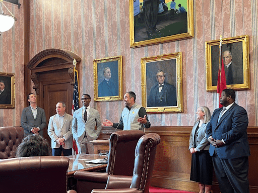
“We believe this will allow us to identify areas across the city that are most in need and then work from there,” said Ward 10’s Councilman Anthony Hairston at a June 16 press conference. “The survey will help pinpoint specific data that will ultimately lead to a better city,” he added, alluding to hot-button Cleveland issues like lead paint abatement and vacancy demolitions. Those issues were a major focus of the meeting at city hall, where Hairston joined Marti, other WRLC staff, Mayor Justin Bibb, and fellow city leaders to announce the data’s release via Case Western Reserve University’s Neighborhood Strategy Technology application.

While the majority of the data is only accessible to those with .edu, .org or .gov email addresses via NST, WRLC published a StoryMap the same day for public use. It helps delineate which health and equity issues are most prevalent across Cleveland’s 82 square miles, but what neither map details are the efforts of the survey teams as part of the nearly $200,000 project.
Here’s how they got it done.
Hitting the streets: what the surveyors did
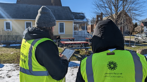
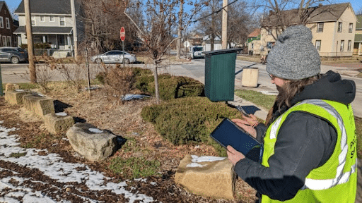
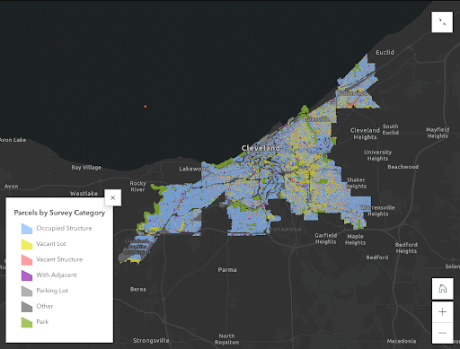
Armed with Android tablets and their iPhones, survey staff spent the mostly mild 2022-23 winter visually combing properties for peeling or missing paint (often a sign of potential lead paint exposure) and illegal dumping. The 53-question survey charged workers with examining staircases and siding, grading roofs, and noting abandoned vehicles – all without leaving the sidewalk.
Marti demonstrated the survey process in front of an abandoned two-story residence at WRLC’s tree yard, located adjacent to the Rid-All Green Partnership farm and food co-op in Kinsman.
“The image is the first part,” he said, taking aim at the crumbling residence with his phone camera. “We asked surveyors to please stand on the sidewalk. Never go on private property.” Marti nudged backward a step.
After he took the picture, Marti started answering a bulky question-and-answer section in the Regrid app, a data entry and mapping software that the surveyors used over the winter. (The service claims to cover over 156,000,000 land parcels in all 50 states.)
The first question for each land parcel is whether the property is one of Cleveland’s 100,000 occupied structures or among its 20,000 vacant buildings. (The other 40,000 or so were either empty or partially vacant lots in varying stages of demolition, which surveyors slotted into a somewhat ambiguous “other” category. A notes section at the end of the survey allowed team members to record any additional comments from themselves or neighbors.)
“Neighborhoods are wanting to see, especially with demolition happening, how many of the vacant homes have been demolished. How has that changed land use? What’s open now?” said Marti.
Marti paced back and forth around the front of the house as his phone continued to prompt him with questions. Did the structure qualify as residential, commercial, industrial, mixed-use, or something else? What is the condition (very good, good, fair, poor, or very poor) of the paint, garage, siding, roof, brick, and sidewalk? (These condition ratings are translated into overall letter grades, A through F, for each property.) Is there an immobile vehicle in the yard, a fire hydrant on the tree lawn or tires and other illegally discarded refuse out back?
“And then, this is an interesting one that [WRLC] added mid-survey,” Marti said as a new query, one asking if the property was in need of immediate inspection, appeared on his screen. “Imagine if you’re a kid. Is there a way [you] could get in here and fall?” He explained that properties where people could easily take a tumble or hurt themselves on debris went directly to the building department for expedited review.
Some days were hard; Marti said on multiple occasions surveyors called off efforts due to the cold in December and January, while others had to confront irate neighbors who were concerned about staff nosing along their tree lawns.
On average, Marti said the team pulled most surveyors from WRLC and neighborhood nonprofits to the tune of between $18 and $20 an hour on a full-time schedule. More experienced inspectors from Cleveland’s building and housing department received higher wages and had bigger workloads.
Each worker spent roughly two minutes reviewing each parcel to learn those answers and fill out the survey. Then, after the information was collected across the city, data analysis could begin.
Turning survey results into actionable data
After surveyors pumped information about the state of each house into Regrid, the data next went to WRLC GIS (Geographic Information Systems) specialist Sadie Jones. She and other data skimmers at the land conservancy then converted the worded survey into raw numbers.
“Something I was really surprised about with the data, we found 20% of parcels were vacant lots,” she told The Land after the press conference. “I knew it would be a high number, but I didn’t know it would be as high as one in five.”
“We tried to intentionally show existing examples we found of vacancy, dumping, and low grades on the west side and north side,” she continued. “That’s one of the biggest things I took away from this too: It’s not just concentrated, [in line] with this former narrative in Cleveland, all in the southeast side. It’s across the city.”
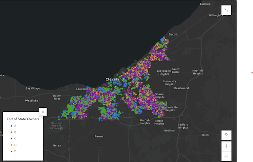
Seeing the big picture is where the StoryMap comes in; it’s meant to translate the survey’s technical results into understandable data. (The NST tool, in contrast, allows specialized users to access granular pieces of data at ward and neighborhood levels.) The StoryMap uses categories such as vacant lots, dumping, lead hazards, and out-of-state ownership to focus on the larger issues in the public consciousness and at city hall.
What’s next
The June 16 press conference illustrated that different Cleveland stakeholders each have ideas for how to apply the data to action. From the perspective of Cleveland Director of Housing Sally Martin O’Toole, the raw numbers can be translated into solutions that will allow the city to be more proactive than reactive about holding people accountable for the state of their property. The city prefers not to be punitive, she said.
To Isaac Robb, WRLC’s VP of planning and urban projects, knowing the condition of the 100,000 occupied structures in the city is an opportunity to make Cleveland healthier by prioritizing lead paint abatement in deteriorating homes. The data will help projects like the Lead Safe Cleveland Coalition, which received $17 million of the city’s federal ARPA money, know where to distribute personnel and equipment.
CHN Housing Partners and Habitat for Humanity will also be more informed about where to focus, he added, and the EPA-funded CLEVLOT vacant land reuse initiative and the Cuyahoga Land Bank’s side yard program use the vacant lot data in their work.
Robb also touched on out-of-town real estate groups grabbing Cleveland land. “We need to continue allocating resources to families and households that were withheld those funds by redlining and blockbusting and then flooded with predatory loans that led to the housing crisis,” he said at the conference. “We must hold out-of-state investors accountable.” The survey data shows owners who live outside Ohio have a tendency to keep lower-grade homes in Cleveland than in-state owners.
The StoryMap, of course, is only a snapshot in time. Marti admitted that some surveyors had to make incorrect judgment calls if it wasn’t clear whether structures were occupied. Other structures slated for renovation received grades that will ultimately be meaningless.
But to Robb, Marti, the surveyors, and the city, that doesn’t diminish the fact that the 2023 property survey has created the most comprehensive directory of Cleveland building information to date. And it will remain that way, only to be superseded by WRLC’s next survey effort, which building and housing director O’Toole has tentatively pitched for 2026.
“We don’t believe residents should have to call when there’s an abandoned house down the street,” she added. “We should be on top of it, and this is our way to get there.”
Readers can email info@wrlandconservancy.org for more about the Western Reserve Land Conservancy’s property inventory survey, tree canopy program, and other initiatives. The full dataset is available via the NST application, housed within Case Western Reserve University’s NEOCANDO database, but it is only immediately accessible to those with .edu, .org or .gov email addresses. Others can request access.
Clevelanders who are aware of structural issues at their home can consult the Heritage Home Program’s loan or the city’s Division of Neighborhood Services, which offers low-interest home repair and enhancement loans. The city’s Building & Housing department can provide additional information. Renters who need help finding suitable, affordable housing can reach out to the city’s rental assistance program, which is run by CHN Housing Partners.
Keep our local journalism accessible to all
Reader support is crucial as we continue to shed light on underreported neighborhoods in Cleveland. Will you become a monthly member to help us continue to produce news by, for, and with the community?
P.S. Did you like this story? Take our reader survey!