
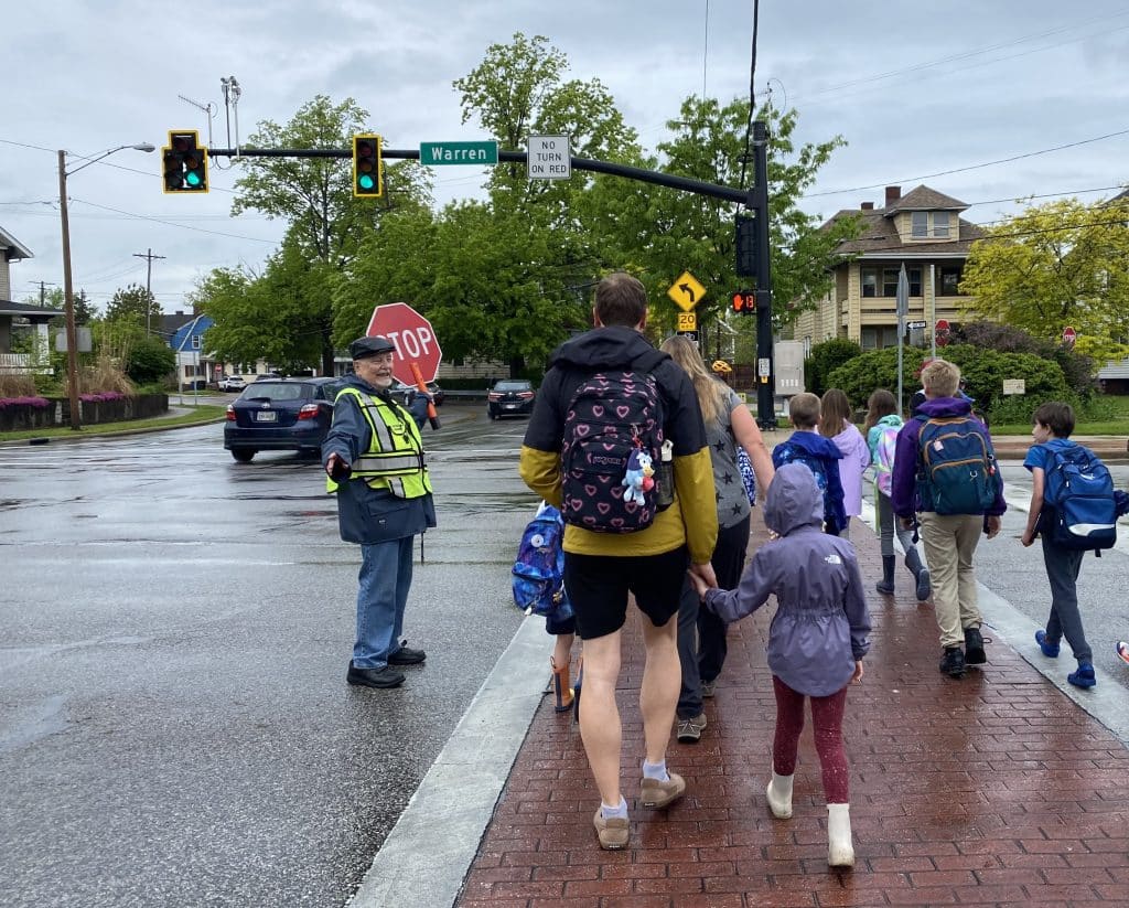
When Joseph Crichton arrives each morning at his busy Lakewood intersection, he dons his crossing guard vest, grabs a whistle and hand-held stop sign, and waits for the neighborhood children to show up.
First it’s high schoolers, a few stragglers walking or biking to beat the early morning bell. Next come the elementary students heading in the opposite direction, groups of youngsters who call Crichton “Mr. Joe.”
Without exception, Mr. Joe knows them all by name.

He can even name their younger siblings. They might be too young to attend Grant Elementary but are happy to toddle along this particular route to school that crosses Lakewood’s high-traffic thoroughfares of Warren Road, Franklin Boulevard, and Hilliard Road.
As a crossing guard, Crichton has a front row seat to interactions between pedestrians, cyclists, and motorists.
There have been close calls between students and cars, according to Crichton.
“A couple big problems are people running the lights and turning when they don’t have the signal to turn. And drivers entering into the crosswalk with vehicles when there are people in the crosswalk.”
Mr. Joe takes his job seriously. And for good reason. Lakewood does not provide bus transportation to school for its students, due mainly to its population and school density, which means that the town’s young students mostly live less than a mile from their school. Kids are expected to walk or bike to their buildings. Yet some parents choose to drive children, citing concerns about the safety of walking or biking on Lakewood’s busy streets.
Nearly everyone that travels within Lakewood seems to have a story of a close call, not to mention two high-profile accidents — including a pedestrian killed by a car in December 2024 and a non-fatal incident in March involving two young children hit while riding in a bike trailer — that occurred recently where Madison Avenue and Hilliard Road meet.
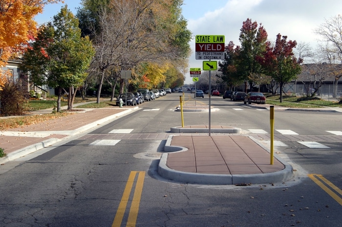
Since those crashes, the city has added traffic delineator posts to the intersection. These small posts offer a visual cue to vehicular traffic and are recommended by experts in places where the boundary between a bike lane and car lane is confusing or unexpected.
Yet many residents want to see more changes at this intersection and across Lakewood. That’s where the city’s transportation plans come in.
In April 2024, city leadership responded to demands for safer roadways by enacting the two-part Safe Streets for Lakewood Active Transportation Plan and Safety Action Plan, which officials say work together to create a safe, connected environment for users of all forms of transportation.
And city officials say they are not done. In May, Lakewood City Council introduced an ordinance that they say would create lasting transportation change.
Safe Streets in Lakewood
More than a year has now passed since Lakewood City Council voted to approve the Active Transportation and Safety Action plans, and many residents wonder: When can I expect to see changes that make my street safer?
The city’s approach is both strategic and practical. The Safe Streets for Lakewood Active Transportation and Safety Action Plans build on prior transportation safety measures developed by city entities over the last 15 years. Examples of previous initiatives include the Safe Routes to Schools Travel Plan (2010) and City of Lakewood Bike Master Plan (2012).
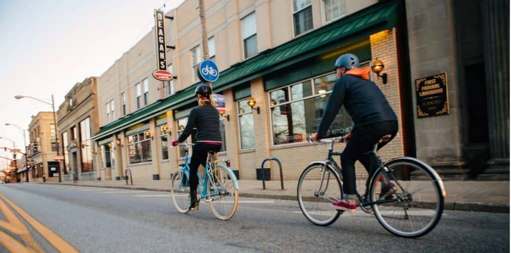
Data and recommendations from those earlier programs form the foundation of the city’s strategic vision and bring Lakewood one step closer to living up to its reputation as the most walkable and bikeable city in Ohio, a distinction measured by Walk Score.
Last year’s plans also set the stage for the newly proposed Complete Streets ordinance, which officials say would help Lakewood achieve “Complete Streets”— an industry-accepted recognition that streets must serve more than just cars — even sooner.
Lakewood City Council President Sarah Kepple suggests that residents think of the 2024 Active Transportation/Safety Action documents as a long-term, big picture strategic plan, whereas the 2025 Complete Streets ordinance is a practical roadmap for how the work gets done.
“Where the rubber meets the road,” says Kepple.
The Active Transportation Plan and Safety Action Plan were the result of a nearly 18-month process that involved city administration, professional consultants, community stakeholders, and public input drawn from multiple surveys between December 2022 and March 2023. Lakewood City Schools and the Ohio Department of Transportation (ODOT) were involved, as well as groups like LakewoodAlive, the Barton Senior Center and Bike Lakewood.
Emily Lindberg represented Bike Lakewood on the stakeholder team. She joined the group in late 2022 and recalls, “We met quarterly from the time it started until [the plan] was approved.”
Another member of the stakeholder team is Lakewood Councilperson Kyle Baker. Baker says that achieving safe streets in Lakewood is the main reason he ran for council in the first place.
“I wanted to get involved in my local community and run for council on this issue,” Baker recounts, “which is street safety, pedestrian safety, safety for people with all abilities and safety for drivers.”
Baker’s vision for improving conditions for pedestrians and cyclists in Lakewood is inspired by the work of Charles Marohn, civil engineer and founder of Strong Towns, a nonprofit that helps cities and towns in the U.S. build what they call “human-oriented streets.” According to Strong Towns, “to build a strong and prosperous community, local leaders must assert their community’s values and see them reflected in the transportation system.”
Even as cars dominate other communities, Lakewood strives to embrace its walkability. Lakewood’s Mayor Meghan George echoed this vision in her message to residents within a recent edition of the city’s newsletter Lakewood Life.
“We are proud to be a city that services those who want a more pedestrian, bike, and transit-friendly community.”
How does the 2024 plan work?
At the core of the Active Transportation plan is the “High-Risk Network for Walking and Biking (HRN)” map within. Officials say this visualization, informed both by historical data and a statistical model based on roadway characteristics, signals which roads have the most potential for crashes involving foot traffic and bikes to occur in the future. These corridors form the basis of Lakewood’s high-risk network. Crash data indicate high concentrations of bicycle and pedestrian crashes along Detroit Avenue, Madison Avenue, 117th Street, Clifton Boulevard, Hilliard Road, and Franklin Avenue.
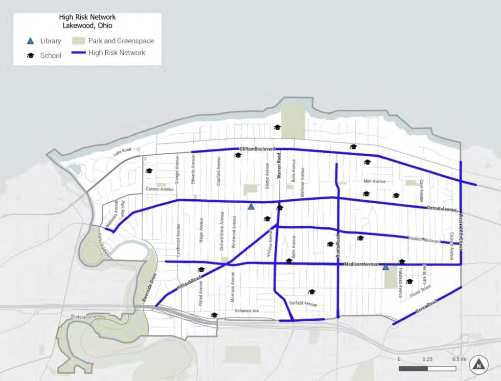
The plan makes specific, customized recommendations for improvements at intersections flagged as highest risk. Improvements range from small changes like curb bump-outs and enhanced lighting, to larger updates like overhauling a street’s sidewalks to create shared use paths.
For instance, the plan recommends that the intersection where crossing guard Mr. Joe is stationed — Warren Road and Franklin Boulevard — sees the installation of high-visibility crosswalk markings. The plan also suggests city engineers should consider raised crosswalks and additional safety improvements for vehicles such as hardened centerlines here.
High-visibility crosswalk markings are also recommended for the intersection of Detroit Avenue and Cove Avenue, in the northeast part of Lakewood. But, according to the plan, that intersection also warrants considering a Leading Pedestrian Indicator, which is traffic signal timing that allows pedestrians to enter the crosswalk several seconds before a vehicle receives a green light. And it recommends a pedestrian refuge island, a raised median that provides a location for people to safely wait for a gap in the traffic.
Building a traffic safety plan is more science than art. To produce each specific recommendation, city planners apply a formula based on attributes like the size of the public right of way — in other words, the land owned by the city that stretches from one sidewalk and tree lawn, across the road, to the tree lawn and sidewalk on the other side — and the layout of the streets and sidewalks for that particular intersection.
The plans form a blueprint that public works leaders can review each time they are drawing up new designs.
Councilperson Baker explains that, in other cities, when a street comes up in the schedule to be updated, public works might repave as quickly as possible and move on. Lakewood’s strategic transportation plans help the city take a more thoughtful approach, asking what Baker says are critical questions.
“What’s best for the community? How can we make [the streets] better? How can we make sure this investment will be more thoughtful and give our residents and visitors what they want?”
Imagine a street is due to be torn up for gas or water line work. To minimize disruptions for residents of that street and maximize the city’s resources, public services will use the occasion to repave the roadway and also make any changes prescribed in the transportation plans. Before breaking ground, they can ask: Is there anything else prescribed for this block or intersection we should add now?
Does this mean every resident of Lakewood can expect to see updates take shape on their street within months?
Not necessarily. Making street improvements is an ongoing process.
“It’s a starting point,” Baker explains. “It’s all about forward momentum to keep going.”
David Baas, assistant director of planning and development for the City of Lakewood, is confident that the plans help the city — whose streets were originally built out to house residents during the time of streetcars — recognize the latest transportation best practices for pedestrian and bicyclist infrastructure.
“Active Transportation in a nutshell is a new, contemporary way to look at how we use the public right of way. All the types of designs from traffic design manuals and standards in the last five years make space for bicycle infrastructure and better designed pedestrian infrastructure,” Baas says.
Baas further explains that the modern approach is about integrating all modes of travel safely, versus the old approach which attempted to completely space out modes of travel like bicycles and pedestrians from cars. That approach is impractical in a dense city like Lakewood where century-old buildings sit adjacent to the public right of way.
Both Baas and Baker emphasize that the plans are carefully written to allow the city access to a mix of federal, state, county and other funding to pay for infrastructure updates. The documents enable the city to meet strict application guidelines and maximize their chances of securing various funds. These grants must then only be used for specific transportation-related projects within Lakewood. In total, the city has earmarked just over $3 million in its 2025 budget for street improvements, traffic signals and sidewalks.
The plans’ other function is just as critical, says Baker, and that is to obtain community engagement in the process.
Residents voice concerns
Not every part of the plan is without controversy.
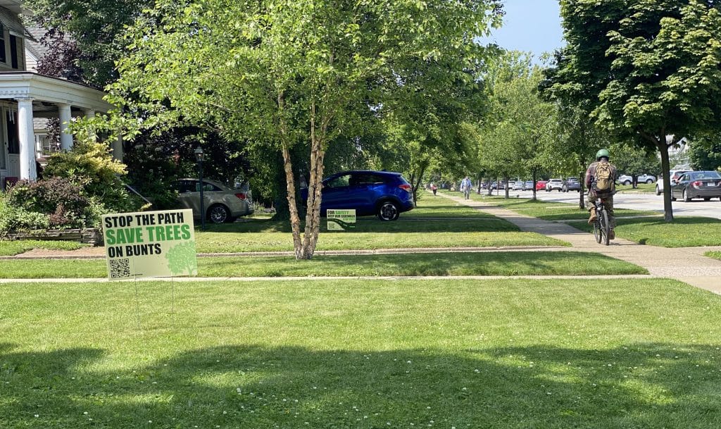
One component of Lakewood’s strategic transportation plan is the construction of a shared-use path on Bunts Road, which is identified as a high-risk network across nearly its entire length from Lakewood Heights Blvd. to Clifton Blvd. The pathway redesign will widen the existing sidewalk on one side of Bunts to accommodate foot and bike traffic. The project was recently awarded nearly $3 million from the Ohio Department of Transportation (ODOT), helping to fund roughly the project’s total cost of roughly $21 million.
Plans were shared with Bunts residents last spring and public comment was accepted on conceptual designs until June 2024. The city expects to break ground in 2026, beginning with the portion of Bunts south of Franklin Boulevard.
However, Lakewood leaders are facing pushback from those who don’t want the shared use path on their street. Bunts residents started a petition, citing concerns that include difficulty for residents pulling in and out of driveways, and signs line the road that call on the city to “Stop the Path, Save Trees on Bunts.”
Several individuals spoke out on the matter during the public comments portion of a May council meeting.
One Bunts resident told council, “We have people up and down the street showing their dissatisfaction clearly.” Another resident felt there are other streets in Lakewood better suited for a shared use path.
One resident who identified themselves as a student said, “This project doesn’t make much sense. The only major destination is the high school. The majority of students who live on Bunts walk to school out of necessity, not by choice.” They, too, asked the city to focus on bike routes that are safer and quieter.
Meanwhile officials maintain they have developed these plans with community input and communicated updates over the project’s timeline. According to their survey, 76 percent of respondents were either in favor or did not oppose the shared pathway design.
Bike Lakewood’s Lindberg, who was part of the Safe Streets stakeholder team, is excited for the project. “The Bunts Path would be our first substantial, well-connected protected space for people outside of cars, and a meaningful step toward a more livable, sustainable Lakewood,” she explained.
“As a parent of two, I strongly support the Bunts Road shared use path. I understand and share the concerns of residents upset about the loss of trees in the public right of way, but it’s important to clarify that these trees are being removed to accommodate necessary sewer work — not because of the path,” she added.
Nonetheless, says councilperson Baker, it’s the city’s job to listen. He says the council will continue to take input on the strategic transportation plans as projects roll out.
“The intent is that the Active Transportation Plan would be updated at least every 10 years, if not sooner,” he notes. “We continue to get new data, new feedback, and best practices from across the country about what we can implement in the future.”
Next steps: Lakewood introduces Complete Streets ordinance
What are “Complete Streets” anyway?
Decades of advocacy catalyzed the U.S. Department of Transportation (USDOT) to build a public health initiative in 2022 to support Complete Streets, the concept of prioritizing safe use for all users, including “people of all ages and abilities, regardless of whether they are travelling as drivers, pedestrians, bicyclists, or public transportation riders.”
Strong Towns’ Marohn writes in his book “Confessions of a Recovering Engineer,”“Cities and states across the country have been adopting Complete Streets policies in increasing numbers…with Complete Streets now being a standard and accepted design practice.”
Since enacting last year’s plans, Lakewood City Council hopes to pass a Complete Streets ordinance this summer that they say would activate their strategic planning and create safety for the most users.
Jointly introduced by Mayor George, Councilmember Baker, Council President Kepple, and Councilmember Cindy Strebig, this ordinance would prioritize any transportation project that involves a route or intersection identified in the Active Transportation Plan and would also create a citizen advisory board.
“Typically when an ordinance is introduced, council has three readings before it would be voted on,” explains Kepple. She expects council to discuss this with the planning commission and the administration during meetings in early summer. As with most council activity, the public is welcome to attend meetings and provide comments.
“With something this big, we certainly want to [get public comment],” Kepple notes.
If the ordinance passes, Lakewood residents could see changes on their street even sooner.
Kepple is especially excited to combine the expertise of city hall with perspectives and lived experiences of those in the community who traverse Lakewood’s intersections daily.
“There will be an opportunity for members of the public who are passionate about transportation,” Kepple explains of the proposed citizen advisory board. “It’s a way for us to engage people with different experiences.”
That could mean involving community members who are primarily pedestrians, who use a mobility device to get around, someone who uses public transit and someone who travels with their children by walking or biking, she describes.
Kepple views community engagement as a critical layer for fostering walkability in Lakewood, alongside infrastructure and community education.
“It’s all these elements that make it safer for folks to walk and bike.”
Other members of council agree. “We must continue to consider every opportunity to increase the safety of Lakewood residents,” says Strebig.
When it comes to paying for the Complete Streets efforts with government funding, however, Lakewood may need to think creatively. It remains unclear what federal funding sources might remain once the federal domestic policy bill is enacted. According to the Associated Press, that legislation contains roughly $3.8 trillion in tax cuts.
And what does Mr. Joe, the school crossing guard enjoying a well-deserved summer break, think about the future of walkability in Lakewood?
No matter when safety improvements roll out at his street corner, he knows it’s always important for pedestrians to be vigilant — especially the children. “Being a busy corner, it keeps one’s attention and you have a good number of kids. Right now, it’s the most I’ve ever seen.”
More information on Lakewood’s 2024 transportation plans can be read here. Residents interested in discussion of the Complete Streets ordinance can attend council and committee meetings.
We're celebrating four years of amplifying resident voices from Cleveland's neighborhoods. Will you make a donation to keep our local journalism going?