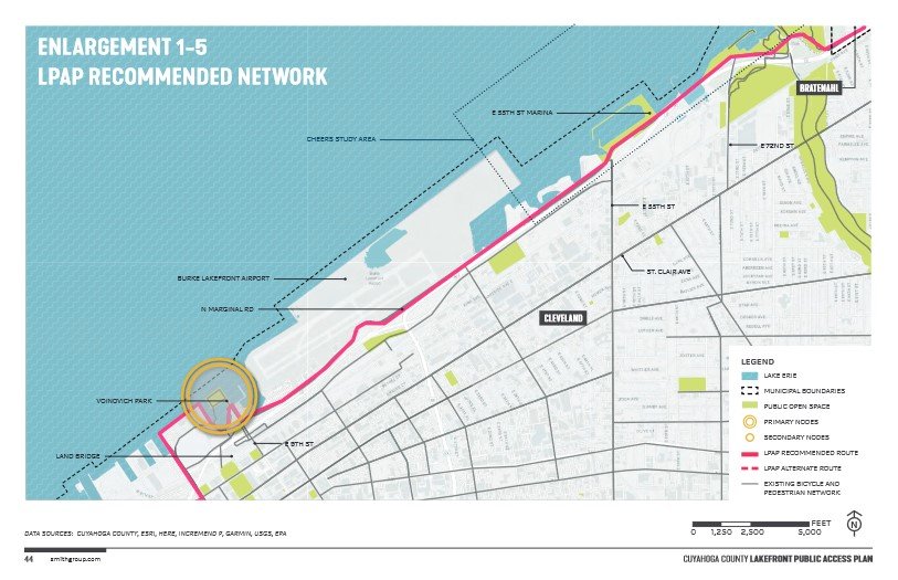


This week, the Cuyahoga County Planning Commission released its new lakefront plan, which calls for a new, paved 2.7 mile trail that would improve connections to the lake between East 9th and East 55th Streets.
That’s welcome news to Jacob Vansickle, Executive Director of the nonprofit advocacy group Bike Cleveland, which has long advocated for improved bike infrastructure in the city, and especially along the lakefront.
“I get at least a dozen calls during the summer from tourists who want to ‘bike the lakefront bikeway’ and often they are disappointed to learn it’s not a trail or stress free bike facility like a protected bike lanes,” Vansickle said via email.
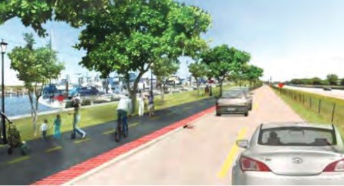
Currently, the so-called “lakefront bikeway” between E. 9th and E. 55th Street consists of a bumpy roadway shared with cars. Cyclists and walkers are shuttled between the freeway on one side and Burke Lakefront Airport on the other before reaching the E. 55th St. marina.
That would change under the county’s plan, which calls for a separate, paved pathway for bikers and pedestrians alongside the roadway. The project would cost about $11 million, according to county estimates. It’s not yet clear how it would be paid for.
View the county’s lakefront plan and sign up for updates
According to the plan, the project would enter the design and engineering phase from 2022-2023 and construction would take place from 2023-2026. Vansickle said the project has the city’s support but the county is set to take the lead on it.
He said by email that the project would have to overcome narrow “pinch points” where there’s not enough width between the roadway and adjacent private property to place a trail. It’s not year clear how the county or engineers would deal with that.
The lakefront plan was announced in 2019 by County Executive Armond Budish. Encompassing the entire 30-mile shoreline of Cuyahoga County, it calls for improved public access, erosion control and mitigation, and enhanced transportation networks along the shoreline.
Cleveland already has some of the best lakefront access in Northeast Ohio, with about 40% of the county’s publicly accessible lakefront located within the city’s boundaries. Now, it could take another leap forward with the construction of a multiuse trail for hikers, bikers and pedestrians along the east side lakefront.
The county plan would dovetail with existing city plans for improving east side lakefront access, most notably a CHEERS eastside lakefront study that is underway now. Since taking over the lakefront reservation in 2013, the Metroparks has made major improvements at East 55th Marina, Gordon Park, Euclid Beach, and Edgewater Park.

The multimodal path from East 9th to East 55th Streets is just one component of the county’s overall plan, which calls for ambitious efforts to control erosion and create more public access along the lakefront. Overall, the plan calls for 50% or 15.1 miles of the county’s lakefront to be publicly accessible.
The county wants to make this happen by working with property owners to obtain easements on their property allowing public access in exchange for shoring up erosion problems. These proposals are modeled after the nationally-recognized work that the the city of Euclid has already done.
For more information about the county’s lakefront plan, visit https://www.countyplanning.us/projects/cuyahoga-county-lakefront-public-access-plan
Lee Chilcote is executive director The Land.
Keep our local journalism accessible to all
Reader support is crucial as we continue to shed light on underreported neighborhoods in Cleveland. Will you become a monthly member to help us continue to produce news by, for, and with the community?
P.S. Did you like this story? Take our reader survey!